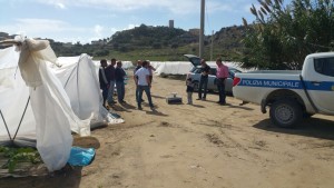
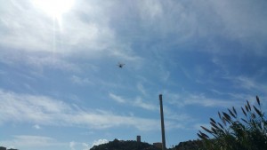
Il primo passo per quantificare i danni creati dalla tromba d’aria abbattutasi ieri sulla città è stata una mappatura aereo-fotogrammetrica delle campagne. L’amministrazione comunale, il comando di Polizia municipale e il dipartimento di Protezione civile si sono avvalsi dell’utilizzo di un drone per riprendere dall’alto i danni creati dalle forti raffiche di vento. Come si ricorderà, ieri è stato chiesto lo stato di calamità naturale.
This website uses cookies to improve your experience while you navigate through the website. Out of these cookies, the cookies that are categorized as necessary are stored on your browser as they are essential for the working of basic functionalities of the website. We also use third-party cookies that help us analyze and understand how you use this website. These cookies will be stored in your browser only with your consent. You also have the option to opt-out of these cookies. But opting out of some of these cookies may have an effect on your browsing experience.
Necessary cookies are absolutely essential for the website to function properly. This category only includes cookies that ensures basic functionalities and security features of the website. These cookies do not store any personal information.
Any cookies that may not be particularly necessary for the website to function and is used specifically to collect user personal data via analytics, ads, other embedded contents are termed as non-necessary cookies. It is mandatory to procure user consent prior to running these cookies on your website.